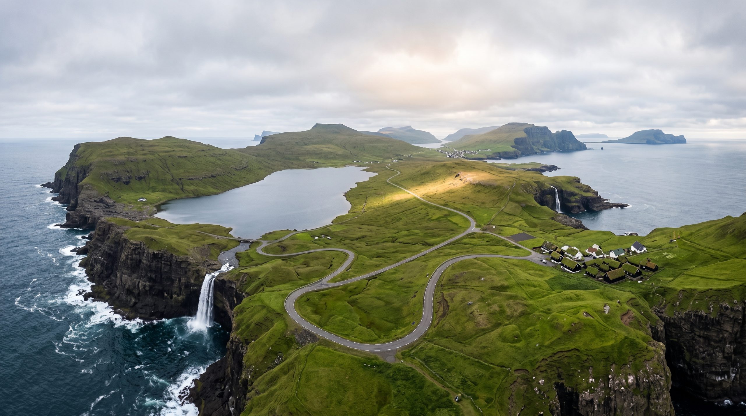
The road west out of Vágar Airport runs out quickly. Route 22 takes you through Sørvágur, Route 45 follows the water to Bøur, then a single-lane tunnel puts you through the mountain into Gásadalur, where Múlafossur drops off the lip of the village straight into the Atlantic. Visit Faroe Islands puts that drive at fifteen minutes. Terminal door to waterfall is a bit over ten kilometers, about seven miles.
That is the quietly useful thing about this island. Almost everything couples fly to the Faroes for sits inside a short radius of the runway, so a compressed route here is not a compromise. The clifftop at Trælanípa, where Lake Leitisvatn appears to hang above the sea, is under five kilometers from the airport in a straight line. Bøur is about the same.
What follows is the version we would give a friend landing on Vágar with one open afternoon: honest drive times rather than route-planner times, the fees you hand over on the ground, and the hours the light actually does something.
What fits inside the thirty-minute radius
Vágar Airport sits beside Sørvágur, and four places sit within half an hour of it: Bøur, Gásadalur with Múlafossur waterfall, the Trælanípa clifftop above Lake Leitisvatn, and Sandavágur. Six hours covers two of them properly, including a walk of two to three hours and the driving between them.
The five stops worth the fuel
Vágar is a short list where every item is genuinely different from the others, which is what makes a compressed route work. One stop gives you height and water. One gives you black-tarred roofs with sea stacks offshore. One gives you the waterfall everybody has already seen and still wants to stand next to.
| Stop | Drive from the terminal (plan on) | Time needed on the ground | What it gives you |
|---|---|---|---|
| Sørvágur harbour | 5 minutes | 20 minutes | Boats and gear, the working face of the island. |
| Bøur | 15 minutes | 30 minutes | Houses stacked above the fjord, Tindhólmur offshore. Roadside, no walking. |
| Gásadalur and Múlafossur | 25 minutes | 60 to 90 minutes | The waterfall over the sea, Mykines out west. |
| Miðvágur trailhead for Trælanípa | 10 minutes | 2 to 3 hours on foot | The 142 meter cliff wall, the lake illusion, Bøsdalafossur spilling 30 meters into the ocean. |
| Sandavágur | 12 minutes | 30 minutes | Shelter and the road toward Trøllkonufingur when the west side is in cloud. |
Mykines is visible from Gásadalur on a clear evening and it is not part of this route. It needs a boat, a return crossing and most of a day, so it belongs to a longer trip.
Where the map lies: Route 45 and the one-lane tunnel
Fifteen minutes to Gásadalur is a real number, on an empty road, in dry weather, with nobody coming the other way. Plan on twenty-five. Here is where the extra ten goes.
Gásadalstunnilin, the tunnel through Knúkarnir between Bøur and Gásadalur, is 1.4 kilometers long and single-lane. Traffic takes turns, so if a coach is already inside when you arrive, you wait. It is completely undramatic and it costs minutes you may have budgeted for light. Route 45 into Bøur is narrow too, edged rather than shouldered, and shared with sheep who have no opinion about your timeline. The tarmac is good. The width is not generous.
The Múlafossur parking area is small, and that is the real constraint at Gásadalur rather than the walking, which takes a couple of minutes from the car. Arrive at midday in July and the viewpoint above the falls is shoulder to shoulder, everybody politely waiting their turn at the same three meters of fence line. It is a flat, crowded hour and we do not build ceremonies into it. Come back at nine in the evening and there is often nobody there but the sheep and one other photographer waiting for the same twenty minutes of light.
At Trælanípa the arithmetic inverts. The drive is nothing, under ten minutes from the terminal, and the walk is the entire cost: roughly 170 meters of climbing, two to three hours out and back, over ground that holds water for days after rain. Footwear decides this timeline, not the car.
The old post route over the mountain into Gásadalur, walked three times a week by the postman before the tunnel existed, is a fine hike and the wrong choice on an elopement day. It is steep, fully exposed to the wind, and it eats the three hours you wanted for the falls.
One more piece of map honesty. Tórshavn is about forty minutes away through Vágatunnilin, the 4.9 km subsea tunnel under Vestmannasund. The published standard tariff for a normal car is DKK 50 each way, with the two directions accounted for together when you are charged from the Vágar side; Faroese rental cars are settled through the rental company, whose own charge can differ. Sleeping on Vágar buys back an hour and a half of daylight, so book a bed within ten minutes of the airport first. The villages here are small.
Vágar light, and a 17:00 to 23:00 route that uses it
The Faroes keep the same clock as the UK, an hour ahead of it in summer, and Vágar sits far enough west inside that zone that the sun peaks around 13:30 in July rather than at noon. Everything about a compressed schedule shifts later than American couples expect. Times below are for Vágar and move a minute or two from year to year.
| Date | Sunrise | Sunset | Where the sun goes down | What that does to the route |
|---|---|---|---|---|
| 20 June | 03:38 | 23:24 | North-north-west | Nearly twenty hours of light, no real darkness. A 17:00 start never feels rushed. |
| 15 August | 05:35 | 21:32 | West-north-west | A long evening block, crowds off Múlafossur by eight. |
| 15 September | 06:57 | 19:52 | Almost due west | The best alignment of the year at Gásadalur, sun going down beyond the falls. |
| 10 October | 08:02 | 18:30 | West-south-west | Ten and a half hours of daylight. One walk plus one village, not two walks. |
| 21 December | 09:54 | 15:01 | South-west | About five hours of light, so the route becomes the whole day. |
At 62 degrees north the sun comes down at a shallow angle rather than dropping, so the low-light window is long. In September you get something like ninety minutes of usable low sun instead of the forty you would get in California. That is why an afternoon here holds more than an afternoon anywhere with a vertical sunset.
Here is a real shape, not an illustration. Mid-July, sunset at 22:57, a ceremony at the lake and the waterfall for the last light. Two locations, one road, no rushing.
- 16:30 Meet at the accommodation in Sørvágur or Miðvágur. Layers on, ceremony clothes in a dry bag, boots on both of you.
- 17:00 Miðvágur parking area. The hiking fee is paid at the office beside the parking area before you set off, and because the guided groups run earlier, the path is emptying rather than filling.
- 17:15 Walking out along the lake. Forty-five minutes of steady uphill, boggy in patches, with the water on your left the whole way.
- 18:15 The ridge above Trælanípa. We work back from the edge, on flat ground, and use a longer lens to give the drop its height. Ceremony here, with the wind doing what it does.
- 18:45 Portraits along the rim toward Bøsdalafossur and the sea stack Geituskoradrangur.
- 19:30 Walk back down, and change out of the boots at the car.
- 20:15 Drive Route 45. We stop on the high road above Bøur while the fjord is still lit, ten minutes, Tindhólmur offshore.
- 20:50 Through Gásadalstunnilin. Coaches are long gone.
- 21:15 Gásadalur. Village lanes first, then the grass above Múlafossur while the sun is still high enough to carry color.
- 22:15 The last forty minutes at the falls, sun sliding north-west past the headland. This is the frame you came for.
- 23:00 Back in Sørvágur in twenty minutes, still light.
Run the same route in mid-September and every clock time moves about three hours earlier, which is often the better trade: cooler air, sharper edges to the cloud, and a sunset that lines up with the falls instead of sitting off to the side.
The gate at Miðvágur, and what the day costs on the ground
Two of the best things on Vágar sit on private land and carry a fee, which is normal here and worth planning for.
- Trælanípa and Bøsdalafossur. The self-guided hike is DKK 200 per person. The guided version is DKK 450 per adult, with the published child rate applying to ages 7 to 14 and younger children free, and the standard guided departures are currently at 09:00, 12:00 and 15:00. Those fixed departures are exactly why a light-driven elopement route often uses the self-guided option, with any ceremony arrangement cleared separately with the landowner.
- Drangarnir. The two sea stacks between Vágar and Tindhólmur can only be reached on a guided hike, DKK 600 per person, running Wednesdays, Saturdays and Sundays at 11:00 from 1 April to 1 October. A fixed 11:00 departure three days a week is a hard thing to build a ceremony around, so if you want it, we plan the day around the tour rather than the other way round.
Permit fees, landowner fees, the celebrant and your accommodation are yours. The research, the emails in Faroese, the timeline and the backup plan are ours, along with team travel: flights and accommodation for the photographer and filmmaker assigned to you are inside the price in every destination, so the Faroes carry no long-haul surcharge. What each coverage option includes is set out on our pricing page, and the shorter option is one full day, which is what this route was built for.
Drones, the airport buffer and what we confirm first
Aerials on Vágar are a question we answer before we design a film around them, never afterwards. European drone rules apply here alongside the Faroese order on drones, BEK 114 of 31 January 2024. Two things in it shape this particular radius.
First, there is a five kilometer distance requirement around Vága Floghavn, which is a meaningful constraint when the whole route lives within a quarter of an hour of the runway. Trælanípa sits right around that five kilometer mark, so we check the official zone map at dronusonur.fo rather than assume. Gásadalur, nearly ten kilometers west, is a different conversation, and there the answer also involves the landowner, because flying over private property needs permission.
Second, between 15 April and 30 August, flying in certain protected areas is limited to authorized operations, which covers a good part of elopement season. Drones from 250 grams up need operator registration and the correct certificate. All of that is groundwork we do in the weeks before you fly, so the film is planned around what is actually permitted at your specific spot on your specific date, and the aerial hour is either in the timeline or it is not.
Two cars, two cameras, and the stop we hold in reserve
One road west means position matters. On a compressed Vágar day with a photographer and filmmaker working together, we run two vehicles: one stays with you, one goes ahead to read the light at Múlafossur and see what the parking area is doing before you commit to the tunnel. Ten minutes of advance information beats an hour of schedule padding. A second set of bodies, lenses and batteries on the island matters too, when the nearest replacement is a flight away.
We also hold a reserve stop you may never hear about. Vágar’s west side and east side get different weather on the same afternoon, so if Gásadalur is in cloud we have Sandavágur and the sheltered ground east of the lake already scouted, with drive times we have actually driven. Highlights reach you five days after the day itself, the full gallery or film three weeks later. Our published elopement stories and films show what these locations look like when the hour is chosen properly rather than taken as it comes.
If you have a flight time and one open afternoon, send it over and we will tell you which of these two locations that afternoon actually reaches. Check Your Date.
Common questions
Can we do this on the same day we land at Vágar?
Yes, in the long half of the year, and it is one of the better uses of an arrival day. With sunset after 22:00 from May into August, a flight landing in the early afternoon leaves a full evening route intact. From October onward we would rather put the ceremony on your second morning than press it against a landing.
How much walking is the Trælanípa viewpoint in a dress?
Two to three hours out and back, about 170 meters of climbing, on ground that stays wet after rain. It is very doable in a dress with boots on and the hem lifted, and most couples change footwear at the top.
Do we need to rent a car?
Every rental company in the Faroes picks up at the terminal, and your own car is the easiest version of this route. Bus 300 runs from the airport if you would rather not drive, though it will not follow a light-driven timeline. Tell us which you want and we build around it.
Is Gásadalur too crowded for a ceremony?
In the middle of a summer day, honestly, yes. The viewpoint above Múlafossur is a small piece of ground and it fills up. The village empties in the evening and it is a different place after nine in July, which is exactly why we schedule the falls at the end of the route rather than the start.
Can you fly a drone over Múlafossur and the lake?
Sometimes, and it depends on the exact spot and date. A five kilometer distance requirement applies around Vága Floghavn, protected areas are restricted between 15 April and 30 August, and flying over private land needs the owner’s permission. We check the official Faroese drone zone map and secure permissions before the aerials go into your timeline.
What actually holds up in Vágar wind?
Merino or wool base layers under everything, a hooded shell you can pull off two minutes before the ceremony, and boots with real grip. For the ceremony hour, a dress with weight in the fabric behaves better than chiffon, though loose layers photograph beautifully here if you accept that your hair will move. Hairpins, not hairspray.
How far ahead should we book a Faroe elopement?
We are booking 2027, 2028 and 2029, and July, August and September go first. A signed contract and a 30 percent retainer open the planning, and from there we build the timeline, the permit research and the backup route.
When one afternoon turns into three days
Plenty of couples arrive intending to use one open evening on Vágar and end up wanting the ferry islands, or the north, or a second morning at the lake before the flight home. That is a different kind of route, two to seven days across one or several islands, and we build those as custom proposals. Our destination guides are a good place to see how the Faroes compare to the other places we work, and the planning fundamentals cover the paperwork side.
Everything between us happens in writing. Send us your dates and your flight times and you will have a reply and our first brochure within a day, then a proposal built on the light for your week rather than a template. Send Us a Message.