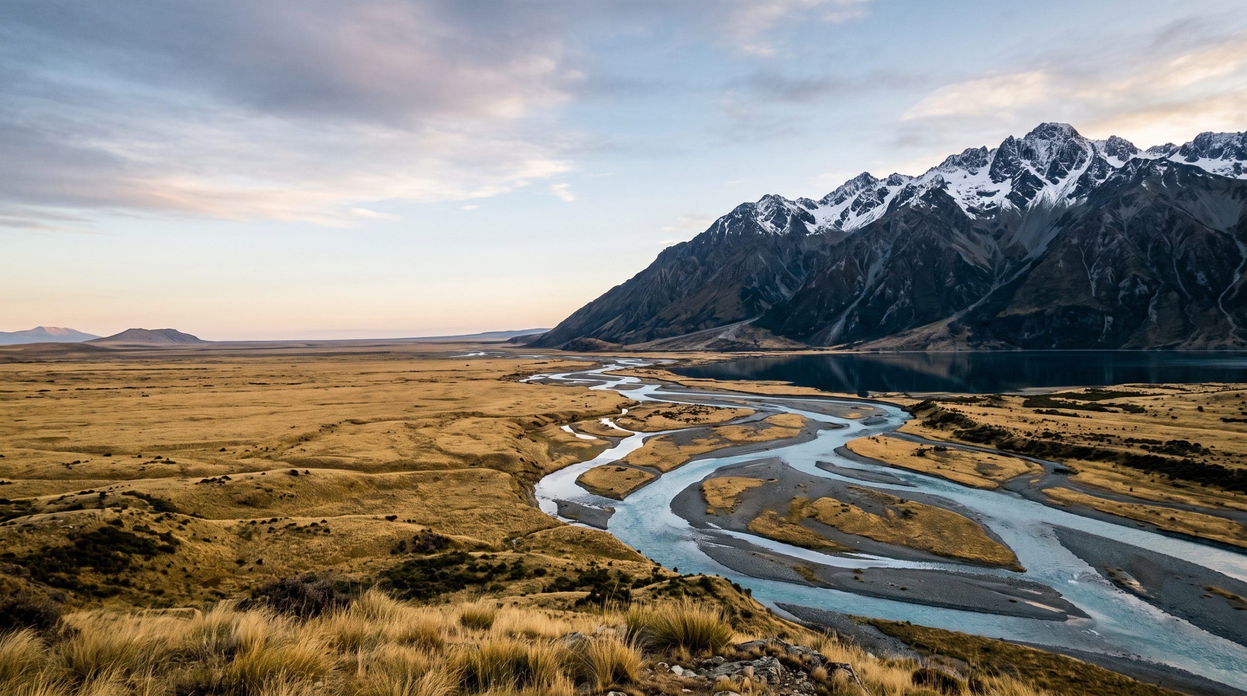
State Highway 80 does not go anywhere. It runs up the western side of Lake Pukaki, past water the colour of milk and blue paint, and stops at Mount Cook Village, where roughly a hundred and fifty people live year round. There is no through road, which is most of the reason the village still feels like arriving somewhere rather than a queue.
In mid-January the sun clears the horizon at Aoraki/Mount Cook Village around 6:10am, and that number is close to useless on its own. The ridge on the eastern side of the Hooker Valley holds the light off the valley floor for a good while after, so the first colour of the day lands high on the faces above you while you are still walking in blue shade on fine gravel. The Hooker Valley Track is five kilometres each way, climbs about 120 metres end to end, and crosses three swing bridges. It is the most walked short track in the national park, and at 5am you will have it entirely to yourselves.
Fiordland runs on completely different arithmetic. Milford Sound Piopiotahi is 300 kilometres from Queenstown, four to five hours of driving each way, and 120 kilometres from Te Anau, at least two hours non-stop. Close to seven metres of rain falls there in an average year, spread across roughly 182 days. Both of those facts are reasons to go, not reasons to stay in the Southern Lakes. Three regions past Queenstown and Wanaka carry most of the work we do on this island, and they ask for very different mornings.
Mackenzie, Fiordland, Catlins: what each one gives you
We photograph and film elopements across three South Island regions past the Southern Lakes: the Mackenzie Basin and Aoraki/Mount Cook, Fiordland from Te Anau out to Milford Sound, and the Catlins coast. One team covers photography, film and planning, coverage starts at one full day, and team travel to all three is included in the price.
What each region asks of you before it gives anything back
None of these three is a substitute for the others. The Mackenzie is dry, wide and high. Fiordland is wet, narrow and vertical. The Catlins is low, forested and salt-blasted, and almost nobody plans a wedding day there. Our destination guides go region by region, but this is the short comparison couples ask for first.
| Region | Getting in | What governs the day | Months we push for |
|---|---|---|---|
| Mackenzie Basin and Aoraki/Mount Cook | State Highway 80, which dead-ends at the village | The eastern ridge, which decides when light reaches the valley floor | January for length of day, late March for night skies |
| Fiordland, Te Anau to Milford Sound | 120 km of State Highway 94, two hours minimum | Rain, and the hours the coaches are in the fiord | Any month, with rain planned in rather than hoped away |
| The Catlins coast | The Southern Scenic Route, east of Invercargill | Swell, wind direction and the light under a forest canopy | October through March |
The Mackenzie Basin and Aoraki/Mount Cook
Aoraki/Mount Cook National Park sits inside Te Wāhipounamu, the South West New Zealand World Heritage Area, and inside the Aoraki Mackenzie International Dark Sky Reserve, which covers 4,367 square kilometres and was accredited in June 2012 at gold tier. The practical meaning of gold tier is that on a clear night in Twizel you can read the shape of the Milky Way from a car park. Two people are very small in this valley, and the frames that work put them small on purpose.
We are honest about the Hooker Valley. It is the most popular short walk in the park because it is genuinely easy, and by ten in the morning the car park at White Horse Hill is full and you will pass people on all three bridges. That is not a reason to avoid it. It is a reason to be at the terminal lake, 877 metres up, before most of them have had breakfast. When the valley is busy or the wind is wrong, the Tasman Valley on the other side of the village and the shoreline of Lake Pukaki give us ground that reads just as large with a fraction of the foot traffic.
Te Anau, the Milford Road and Fiordland
State Highway 94 climbs faster than any other highway in the country and tops out at 940 metres. Over summer peak periods, traffic lights control the flow through the Homer Tunnel and can add up to twenty minutes to your drive, which is exactly the kind of detail that quietly ruins a timeline written by someone who has never driven it. The stretch between the Hollyford Road junction and The Chasm is a restricted no-stopping zone, so we plan frames on either side of it and nowhere in between. From May to September the road runs on winter rules and drivers are advised to carry chains, so we build those days to start late and put the fiord in the middle of the day rather than at first light.
December and January are the two wettest months in Milford Sound, which surprises couples who assumed summer meant dry. Rain is what makes the walls run with water, and a fiord in heavy rain grows hundreds of temporary waterfalls that film handles better than stills do. We would rather plan the wet version properly than sell you a forecast nobody can promise.
The Catlins and the Southern Scenic coast
New Zealand’s own tourism board describes the Catlins as “the most unsung of South Island regions”, which is unusually accurate for that kind of writing. Nugget Point Totāra Scenic Reserve gives you a lighthouse on a spine of rock with sea on both sides, reached on a short walk from the car park. Purakaunui Falls drops twenty metres in three tiers a few minutes from a road end. Curio Bay holds a petrified forest more than 160 million years old. At Nugget Point on 21 December the sun is up at 5:44am and does not set until 9:33pm, which is a long day to work with on a coast almost nobody books.
The forest here is several stops darker than the coast, so we shoot the waterfalls in flat light and keep the headlands for the beginning and end of the day. This region suits couples who want a wedding day with kelp and wind in it rather than snow.
Sixteen hours of light: how a January day at Aoraki runs
Mid-January at Mount Cook Village gives you civil twilight from about 5:35am and usable light until nearly 10pm. Sixteen hours is more day than any couple wants to be photographed for, so the real work of the timeline is deciding which two hours matter and protecting them.
We meet at the White Horse Hill car park at 4:45am and start walking by five, head torches on, because the track surface is formed gravel and easy underfoot in the dark. First light reaches the tops around 5:35am. Official sunrise is 6:10am, and the valley floor stays cool and blue for a while after that, which is the light most couples have never seen photographs of because almost nobody is standing there at that hour.
Vows happen between about 6:30 and 7:30am, at a spot we choose the previous evening based on wind direction rather than on a map pin. The up-valley breeze builds through the morning, and it decides where a celebrant can be heard and where a veil behaves. We walk out from around 9am, passing the first wave of day walkers coming in, and by then the important hour is already recorded.
Then we stop. Four hours off in the middle of the day is not us saving effort, it is the reason the evening works. We are back out around 5pm in the Tasman Valley or on the Pukaki shoreline. Sunset is 9:23pm in mid-January and the light holds until about 9:58pm.
If night frames under the dark sky reserve matter to you, know that full astronomical dark in mid-January does not arrive until nearly 11:40pm. In late March it comes at about 9:30pm, and by then the crowds have thinned as well. That is the single most useful thing we can tell an American couple choosing between January and a shoulder month. June runs the other way entirely: the sun rises at 8:14am and sets at 5:09pm, which makes a winter day here the easiest sunrise in our whole calendar.
Wind, gravel and five kilometres: why the film and the photographs are one job
A photographer and a filmmaker want different things from the same swing bridge. The filmmaker needs you to walk it once, cleanly, and probably again from the far side. The photographer needs you to stop in the middle and forget the camera. Two people hired separately, seeing each other for the first time in a dark car park at 4:45am, negotiate that on the bridge while the light they came for happens above them. We settled it weeks earlier, in one timeline written by the people who will shoot it.
In these specific landscapes the difference is not abstract. The Hooker Valley wind builds through the morning, so vows get placed early and in a sheltered pocket, and on The Expedition the audio recorder goes on before the wind does. Drone use on public conservation land needs a permit whether you are a business or a visitor, so aerials are planned against a permission and a weather window, not attempted on impulse. In Milford, rain that makes a photographer work hard is the exact condition that makes the film good, and knowing that in advance is what stops a wet morning from feeling like a loss.
Eight of us do this work. Serg, Alex, Alex and Viktoria shoot photographs; Lara, Mike, Anthony and Stas make the films. That number is why there is always a second camera on the ground and a colleague in reserve, and it is why the finished work looks like one authored day rather than two files that happen to share a location. Our published galleries and films are the fastest way to judge whether that difference is visible to you, because it either is or it is not.
If a January dawn in the Hooker Valley or a wet afternoon in the fiord is the day you keep picturing, write to us and check your date.
What the day covers, and where it starts
Every experience includes destination and location design, full planning, a custom timeline built around light and real travel time, permit research and logistics guidance, weather alternatives and backup planning, and drone footage where it is legal, safe and appropriate. The Expedition adds professional audio for vows and other meaningful moments where conditions allow. Highlights land with you in 5 days, and the full gallery or film in 3 weeks.
Team travel is included worldwide, so flights, accommodation and ordinary travel for the assigned team are already in the figure. The price does not move with guest count either. Bringing four people changes access, permits, transport and the timeline, not the fee.
- The Adventure, from $4,900. One full day with a dedicated photographer or a dedicated filmmaker.
- The Expedition, from $7,900. One full day with a dedicated photographer and filmmaker working together.
- The Odyssey. Two to seven days, photography and film, one region or several, quoted as a custom proposal.
There is no half-day option, because half a day in the Mackenzie means driving four hours to stand in the wrong light. Full detail sits on our pricing page.
Costs you pay directly, in New Zealand dollars: the marriage licence, currently NZ$150 when you marry with a celebrant, applied for at least three working days before the ceremony and valid for three months; your celebrant; accommodation, which is limited and books early at Mount Cook Village in particular; and any government, venue or landowner permit fees, which are set by the Department of Conservation for activity on public conservation land and vary by site and activity. Unusual transport is separate too, which out here usually means a helicopter onto a glacier, a private boat on the fiord or a 4×4 charter.
From your first message to the day planning starts
- You send the inquiry form with your rough dates and whichever region has your attention.
- We reply within 24 hours with our initial brochure.
- We ask what you actually want the day to feel like, and what you would rather avoid.
- We write a tailored proposal for the region, the month and the shape of day that fits.
- You sign the contract and pay a 30% retainer. The rest of the payment plan is set out in the proposal.
- Planning begins: permits, timeline, celebrant coordination, alternatives for every hour.
If you are earlier than that and still working out the order of things, our guide to how to elope covers the fundamentals before any of this becomes urgent.
When Aoraki is in cloud and the fiord is full of rain
This is the question we get most about the South Island past Queenstown, and it deserves a straight answer. Aoraki is often in cloud. Milford is often wet, on around 182 days a year. Neither fact is a problem you solve on the morning by hoping harder.
What we do instead is geography and preparation. The Mackenzie sits east of the main divide and stays dry when the West Coast is being emptied on, so a low cloud base at the village usually still leaves the Pukaki shoreline, the Tasman Valley and the braided riverbeds working. In Fiordland we plan the wet version first and treat a clear day as the upgrade. Every timeline we write carries a named alternative for each block, chosen on the ground rather than invented over email at midnight. Your licence names where you intend to marry, so we settle that one point early and keep everything around it movable. And because coverage can run across two to seven days, a longer shape buys you the option to wait a weather system out without paying for a second round of team travel.
Who does well out here: couples genuinely fine with a 4:45am start and ten kilometres of easy gravel, and relaxed about a plan that changes shape the night before. Couples who want none of that are not a problem either. The Catlins gives you a lighthouse and a three-tiered waterfall within minutes of a car park, the Mackenzie has lake-shore ground five minutes from the road, and a June day at Aoraki starts at 8:14am. Tell us which of those sounds like a good morning and we will build the day around it, or tell you which month fits it better.
Common questions
Do we need a permit to elope in Aoraki/Mount Cook National Park?
Commercial activity on public conservation land runs on permission from the Department of Conservation, and that includes professional photography and filming. We handle the research and the logistics of it as part of planning. Where a fee applies, DOC sets it by site and activity and you pay it directly.
Can you fly a drone over the Hooker Valley?
Drone use on public conservation land requires a permit, for commercial and recreational flying alike. When aerials matter to your film, we plan them against a permission and a weather window rather than deciding on the day. Where that is not available, the film is built without them.
How far ahead do we need a New Zealand marriage licence?
You apply at least three working days before the ceremony, and the licence stays valid for three months, so most couples apply a few weeks out. It currently costs NZ$150 when you marry with a celebrant. You also need a celebrant and two witnesses, and the licence names the place you intend to marry.
Is it worth driving to Milford Sound for the day, or should we stay near Te Anau?
Milford is 120 kilometres from Te Anau and at least two hours each way, plus tunnel delays of up to twenty minutes at summer peaks. It is worth it when the fiord itself is the reason you are coming. If it is not, the Te Anau end of Fiordland gives you lake, beech forest and mountains without four hours in the car.
What happens if the mountain is in cloud all day?
We move to the alternative we already chose for that hour, usually lower and closer to water, and we tell you the night before rather than at 4am. A cloud base that hides the summit often improves the valley, because the scale stops competing with the two of you.
Which month is best, and does winter work at Aoraki?
January gives the longest day and the biggest crowds. Late March gives dark skies by about 9:30pm and quieter tracks. June works well for couples who dislike early starts, with sunrise at 8:14am and sunset at 5:09pm, and the Milford Road on winter rules from May to September.
Can you cover two regions on one trip?
Yes. The Odyssey runs from two to seven days across one region or several, which is the usual answer for couples who want both the Mackenzie and Fiordland. It is quoted as a custom proposal because the driving and the permits differ every time.
When do we get the photographs and the film?
Highlights reach you 5 days after the day itself, and the full gallery or film within 3 weeks. That timing is the same in every region and does not stretch because we were somewhere remote.
Picking your summer: 2027, 2028 or 2029
We are booking all three of those years now, and the region usually decides itself once you know which month you can travel. Every planning step stays in one written thread, at whatever hour suits you, from your first message to the final timeline. You never need to be awake at the same time as us.
Send us the month, the region you keep coming back to, and the kind of morning you actually want. We will tell you plainly what that day looks like out here and what it takes to make it happen. Tell Us Your Story.