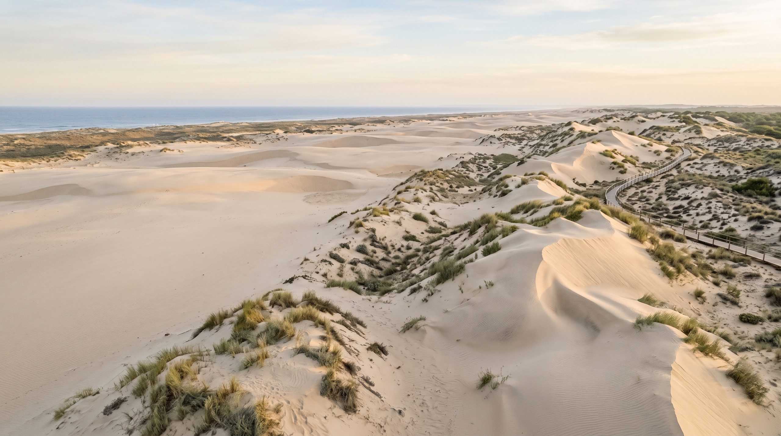
The walkway at Cuesta Maneli is 1,371 metres long. All of it is timber laid over loose sand, it climbs the fossil dune and crosses open scrub with no shade at all, and it finishes at a viewpoint where a flight of steps drops you onto the beach. That last stretch is the part nobody writes about, and it is why we build a Doñana day backwards from the walk rather than forwards from the ceremony hour.
Doñana is not a place you can simply stand in. The national park covers 54,252 hectares of marsh, mobile dune and pine forest across the provinces of Huelva, Seville and Cádiz, about 50 kilometres southwest of Seville, and its protected core is reached only on a guided vehicle route booked in advance. What you can use is the boundary. An Atlantic beach runs the whole length of it, a wall of ancient sand stands at the western end, and a pilgrimage village sits on the marsh edge to the north.
Get that geography right and you have a coast with almost nothing built on it at all. Get it wrong and you spend the afternoon on a town beach with a promenade behind it, hunting for a parking space.
Where a Doñana ceremony actually happens
Not inside the reserve core, which opens only to booked guided vehicles. It happens on the seaward edge: Playa de Castilla, the undeveloped Atlantic sand that runs roughly thirty kilometres from Matalascañas to the mouth of the Guadalquivir, the fossil dune cliff reached from the Cuesta Maneli boardwalk, and the sand streets of El Rocío above the marsh.
1,371 metres of boardwalk, in a dress
The Cuesta Maneli path is signposted off the A-494 between Matalascañas and Mazagón, with a car park at the road and no charge to use the walkway. From the barrier it is 1,371 metres of raised timber to the viewpoint, and then steps down the sand face to the beach. The Andalusian environmental authority publishes that length precisely, which tells you something about how carefully this dune is managed.
In wedding clothes, allow twenty minutes each way at a pace that respects a hem, and more if the dress has any length to it. Timber slats and heels do not work together, so we plan for flat shoes on the walkway and a change at the top of the steps. Sand gets everywhere on the descent. It is fine, dry, pale sand that shakes out of a suit easily and lodges in a train permanently, which is a real consideration rather than a fussy one, because you may want the same dress at dinner.
The reward at the bottom is the Acantilado del Asperillo, a fossil dune system spread across about twelve hectares of coast and protected as a Natural Monument. The sand face rises around thirty metres above the beach, cut into vertical channels by rain, and the oldest material in it is estimated at fourteen to fifteen thousand years old. Stand at the base and there is nothing modern in any direction. No building, no railing, no bin.
If a long walk is not the right way for you to arrive at your own ceremony, the beach east of Matalascañas is flat and reachable in minutes, and the day can be shaped around that instead without losing the coastline. Say which of those two mornings sounds better and we will build the timeline to match.
The sixty-degree swing in where the sun goes down
The shoreline from Matalascañas to Mazagón runs on a bearing of 301 degrees, which means the sand faces south-southwest and the sea occupies everything from the southeast round to the northwest. The sun sets over water here every day of the year. Where it sets moves enormously.
In late December the sun goes down at roughly 241 degrees, out in front of you over open Atlantic, at about a quarter past six. By late June it sets at roughly 301 degrees, which is the exact bearing of the coastline, and it does not go down until nearly ten at night. That midsummer alignment is the best thing about this beach and hardly anyone plans for it: the sun drops at the far end of the sand, lighting the whole shoreline end to end, with the wet strip at the tide line working as a mirror all the way to the horizon.
Mornings are the opposite story. The dune ridge and the cliff stand on the northeast side of the beach, so the first hour of daylight lands on the top of the dune and leaves the sand at the base of the cliff in shade. The cliff face takes direct light from mid-afternoon and holds it until the sun goes. Late December is the exception, when the sun rises at about 119 degrees, almost straight up the line of the beach from the southeast, and the sand is lit early.
Midday is honestly the weakest hour on this coast. Pale sand under a high sun goes flat, contrast disappears, and the cliff loses all its texture. We would rather have you at the cliff for the last ninety minutes of the day and in the pine forest or the village at noon. In June that means the walk back along the boardwalk happens in the dark, so we carry lights and put the flat shoes back on before we start. You can see how the sand face and the low light read in our published galleries and films, which is the fastest way to judge whether this coast is the one you want. Highlights reach you five days after the day itself, and the full gallery or film three weeks later.
Standing room shapes how two of us work here. On the boardwalk there is none: it is a single narrow deck with railings, so the photographer works close while the filmmaker holds the long view back along the curve, and we leapfrog rather than flank. On the open beach the problem inverts, because there is unlimited room and nothing at all to break the onshore wind. Vows go in the lee of a dune or against the base of the cliff, where the air is quieter, and on an Expedition the professional audio for that moment is part of the plan rather than a hope.
The fallen tower, the promenade and the parking problem
The most photographed object on this coast is the Torre de la Higuera, a watchtower finished in 1577 as one of eleven along this shore, now lying broken on the sand at Matalascañas and protected as a Bien de Interés Cultural. Locals call it La Peña, El Tapón or simply La Piedra. It is genuinely good, and it sits on the town beach with a four-kilometre promenade behind it, restaurants, showers and lifeguards, and a parking squeeze in season that arriving early does not solve.
In July and August the answer at Matalascañas is not an earlier hour, it is distance. Walk east along Playa de Castilla and the crowd thins within twenty minutes because the park boundary runs there and nothing is built beyond the last apartments. Or use Cuesta Maneli, where the length of the boardwalk filters out almost everyone who was not committed to the walk. Outside the Spanish summer, both places are close to empty on a weekday, and the tower is a serious location again rather than a queue.
Sand streets and standing water at El Rocío
El Rocío is fifteen minutes inland from the coast road and it does not look like anywhere else in Andalusia. The streets are deep sand rather than asphalt, houses have hitching rails outside them, and horses are working transport rather than decoration. It photographs beautifully in the hour after sunrise, when the sand streets are empty and the low light runs straight down them.
In front of the village is the Madre de las Marismas, the northern lip of the wetland. This is the part that changes most between one visit and the next. In a wet winter and through spring the marsh holds water and the whole view turns into sky on a mirror. By late summer it can be dry ground. Neither version is wrong, but they are completely different pictures, and it is worth deciding which one you are travelling for before we set a month.
El Rocío is also a pilgrimage village, and its own calendar matters more than the tourist one. Certain spring dates fill every bed in Almonte, so we check what the village has on before we lock a May or June plan. If you want the marsh full and the village quiet at the same time, tell us that when you write to us and we will tell you honestly which weeks in the year do both.
The park interior is a visit rather than a venue, and worth doing on your own account. Guided four-wheel-drive trips leave the El Acebuche visitor centre at kilometre 37.5 of the A-483, run about four hours over roughly seventy kilometres of dune, forest and marsh, and have to be booked ahead. Two departures a day, morning and afternoon, with the afternoon time shifting between the summer and winter schedules. We build that around the day rather than into it, usually on the day before.
Who has to say yes, and who does not
The legal marriage is the simplest part to explain and the part most pages muddle. Spanish civil marriage is built around residency: one of you needs to have been legally resident in Spain for two continuous years for a civil ceremony to be approved. Visiting couples therefore handle the legal paperwork at home and hold the real ceremony here, with a celebrant, their own words and whoever they want present. Our guide to planning an elopement sets out how that sequence works in practice.
The beach is public land. A ceremony for two with no arch, no chairs and nothing left behind sits in a very different category from an event, and on the open sand at Matalascañas that is straightforward. Inside the protected space it is stricter, and correctly so. The Cuesta Maneli walkway lies in Reserve Zone A of the natural park, and Andalusia requires written authorization for professional filming and photography in protected areas. It also requires authorization for anything using auxiliary equipment such as lights, reflectors or generators, professional or not. Doñana has its own 1999 law on top of that, which makes filming in the special protection zones without authorization an infraction wherever the prohibition is posted.
In practice this shapes the craft, not just the paperwork. We work with available light and nothing on a stand, which is how we would shoot this coast anyway. Aerials over the protected zone run on the same authorization route, so we confirm the permission and the window before anyone plans a film around a drone shot. The research, the applications and the guidance are ours; the government or landowner fee, where one applies, is yours. One dedicated photographer or one dedicated filmmaker for a full day starts at $4,900, and a photographer and filmmaker working the day together starts at $7,900, with the multi-day option and everything included in each set out on our pricing page.
The far bank, from Sanlúcar de Barrameda
There is a second way to meet Doñana, and it involves a boat. Open craft cross the Guadalquivir from Playa Bajo de Guía in Sanlúcar de Barrameda to the park’s far shore, where the visitor centre in the old ice factory sits on the town side. On foot the beaches over there are open to you. Taking a motor vehicle across into the park needs specific permission, and private crossings can be arranged with the operator. It swaps a boardwalk for a river, sherry bodegas for pine forest, and gives a day two very different halves.
Common questions
Can we legally get married inside Doñana National Park?
No, and not just because of the park. A Spanish civil marriage needs one partner to have been legally resident in Spain for two continuous years, so visiting couples marry legally at home. The ceremony itself, with a celebrant and your own vows, happens on the beach or in the dunes on the park boundary.
How long does the Cuesta Maneli boardwalk take in a wedding dress?
The walkway is 1,371 metres in each direction, plus steps down the sand cliff to the beach. Allow around twenty minutes each way in wedding clothes at a comfortable pace. Flat shoes on the timber, a change at the top of the steps, and a plan for how much sand your dress will keep afterwards.
Is Matalascañas beach too crowded for a ceremony in August?
The town beach beside the fallen tower is, and an early start is not enough to fix it. Twenty minutes walking east along Playa de Castilla takes you past the last buildings onto undeveloped sand, and the Cuesta Maneli boardwalk filters out most people by existing. Outside Spanish school holidays, both are quiet on weekdays.
Which airport should we fly into for Doñana?
Seville. It is around 67 kilometres to Almonte and roughly an hour by car, with El Rocío and Matalascañas beyond it on the A-483. You want a hire car regardless, because the coast road, the boardwalk car park and the village are all separate stops and the good light sits at both ends of the day.
Do we need permission to fly a drone over the dunes?
Over the protected space, yes. Andalusia requires written authorization for professional filming in protected areas, and Doñana’s own legislation reinforces it for the special protection zones. We research and apply for what a specific location needs, confirm the window, and only then plan a sequence that depends on aerials.
Does the boat from Sanlúcar de Barrameda run early enough for us?
The crossings from Playa Bajo de Guía work through daylight hours, and the operator will arrange a private crossing on request. For a first-light plan we confirm the actual first departure for your date rather than trusting a published table, and we hold a Matalascañas alternative in case the river is not co-operating.
One day, cliff to marsh
A Doñana day we like starts in the sand streets of El Rocío while they are still empty, moves to the pine forest and the marsh edge through the flat middle hours, and then commits everything to the coast. Boardwalk at Cuesta Maneli in flat shoes, change at the viewpoint, ceremony at the base of the Asperillo in the last ninety minutes of light, and the walk back under headlamps with the Atlantic still audible behind you.
All of our planning happens in writing, which means you read it when it suits you and not at some hour dictated by Spanish time zones. Send us the shape of the day you want and you will have a reply and our brochure within 24 hours, then a tailored proposal; a signed contract and a 30% retainer start the planning. We are currently taking Andalusia elopement bookings for 2027 through 2029, and there are eight of us, so there is always a second camera on the ground and a colleague in reserve. Start Your Story.