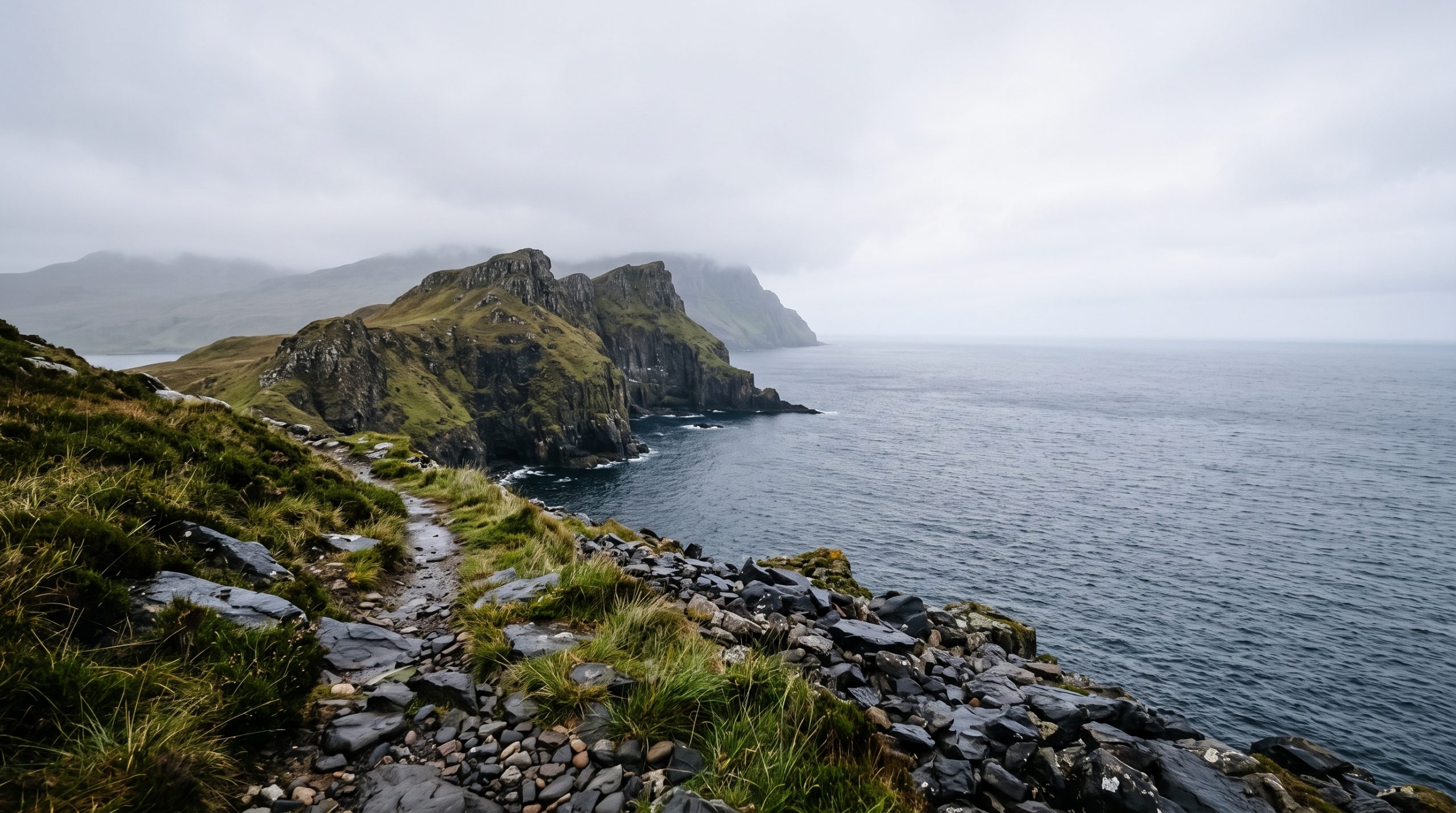
The wooden footpath sign at Culnacnoc reads Rubh’ nam Braithrean. The Ordnance Survey sheet for Trotternish, Explorer 408, spells it Rubha nam Brathairean. There is no brown tourist sign, no visitor centre and no car park worth the name, and that mismatch is most of the reason this headland stays quiet while a viewpoint a couple of minutes up the same road absorbs coach after coach.
Brothers’ Point is the easternmost tip of the Trotternish peninsula: a narrow promontory of grassy plateaus running out into the Sound of Raasay, flanked by rock ridges and stacks, and finished with the steep-sided stump of Dun Hasan. Sauropod and theropod footprints were recorded on the tidal shelf below in 2018, pressed into rock that was a warm lagoon roughly 170 million years ago. Ruined crofts sit above the shore, and on the point itself there is the line of an old wall long thought to mark a small monastic site, which is where the brothers in the name most likely come from.
We photograph and film ceremonies out here, and we plan them from the walk backwards. What the path is like in a dress, when the sun clears the sea, how long low water leaves the shelf uncovered, where the day goes if the burn near the shore is running full. That is what this page is for.
What Scots law allows on an unfenced headland
Scotland lets you marry legally outdoors with no licensed venue involved: you need an authorised celebrant or registrar, two witnesses and a valid marriage schedule. Notice goes to the Portree registration office on form M10, no earlier than three months and no later than 29 clear days before the date, at £45 per person.
Nobody issues a permit for the headland itself. Scottish access rights cover walking out here, the ground is working croft land with sheep and gates rather than a venue, and five people standing on grass do not need a ticket or a booking. The paperwork is the part that has a deadline. Both of you lodge the M10 with the district registrar, the marriage schedule is collected in Portree before the day, and it is signed and returned within three days afterwards. Our planning covers that sequence, the celebrant search, and any landowner or authority permission your particular day genuinely touches, while the statutory fees stay yours to pay. If you are at the beginning of all this, the groundwork for planning an elopement is the better place to start than a location page.
A lay-by, a wooden sign, and no other clue
The start is a lay-by on the A855 at Culnacnoc, around 13 miles and 25 minutes north of Portree, on the left as you drive towards Staffin. It sits about 40 metres north of the Glenview turning and before the houses, it is free, and it holds a handful of cars rather than a coach party. The path begins on the opposite side of the road, a short way back south, at that wooden sign. Grid reference NG 516 625 if you want it on a map before you fly.
The 57 bus runs four times a day from Portree and stops at the Glenview, which is a fine way to see the headland on a scouting trip and a poor way to arrive with dress bags and a tripod. On a wedding morning we set the arrival order in advance so nobody is reversing on a single-lane verge in good clothes, and so the two vehicles that matter get the spaces.
Walking down in wedding clothes
The full round trip is 3.5 kilometres, about 2.25 miles, and most people take between one and two hours without stopping to get married halfway. The important thing about the shape of it is that the walking is downhill on the way out and uphill on the way home. You lose height from the road almost immediately, which feels generous at nine in the morning and less generous seven hours later with flowers in one hand and a hem in the other.
Past a couple of buildings and a gate, you turn right onto a signed track, then fork left onto a path that drops away downhill. That upper section is an old, well graded grassy line, genuinely easy going, and it is the part that surprises couples who were braced for something rougher. Lower down, where the ruined crofts come into view, the path bends right along a fence and ends just short of the shore. From there it is sheep-cropped grass, patches of bog that hold water for days after rain, and a burn to step over near the bottom.
In wedding clothes, the honest summary is this: walk it in boots, change on the grass. Peat water does not come out of silk on the day, and a long hem dragged through wet ground on the way down will still be wet at the ceremony. We carry a bag, we build fifteen minutes into the timeline for the changeover on the flat grass above the shore, and the boots come back on for the climb out. A veil on an east-facing headland is a two-hand job, so if you want one we plan who is holding what before the celebrant starts.
None of this is hard. It is a walk, not a climb. But it does mean the place rewards a couple who are happy to be slightly windblown and to spend twenty minutes of their morning going uphill, and if that is not the day you have in mind, tell us. There are places on Trotternish where the ceremony ground is two hundred metres from a car, and we would rather put you there than watch you fight the ground.
The grass saddle below Dun Hasan
The ceremony does not happen at the tip. Reaching the true end of the point means a steep, narrow scramble up the stump of Dun Hasan, which was itself an ancient fort, and that is a hands-out-of-pockets kind of path rather than a place to stand and read vows. The ground that works is the grassy saddle before it: level enough for a celebrant and witnesses, high enough that the stacks and the Sound sit behind you rather than beside you, and small enough that the whole ceremony feels held by the shape of the land.
There is room for two of us to work out here, provided we split levels rather than share a sightline. One of us drops onto the shelf below the saddle for the long lens and the sea behind you, the other stays high on the slope for the wide frame, and neither appears in the other’s shot. That is the practical reason photo and film come from the same team on our side: two people who have not worked together before end up negotiating for the same three metres of grass while a celebrant waits. Wind matters more than either camera here, because an easterly comes straight up off the water into a lapel mic, so audio gets placed in the lee of a body or a rock rather than optimistically clipped and hoped for. You can see how coastal ground like this reads in finished work in our galleries and films, where the headland almost always looks better with the two of you small in it.
Light that arrives out of the sea and leaves early
This is the part most location guides get backwards. Brothers’ Point faces east and northeast into the Sound of Raasay, so the sun comes up out of the water, over Raasay and the mainland hills beyond it, and rakes along the ridges of the promontory from the side. At 57 degrees north in June it rises well north of east, so that first light runs up the coast rather than straight down it, and the grass and the stacks separate beautifully for an hour or so. That hour is early. It is also the best light this headland gets all day.
By mid-morning the sun is high and off the water, and the point flattens. Late in the day it goes behind the Trotternish escarpment inland long before the published sunset, and the headland drops into shade from the ground upward while the sky above is still bright. So the plan that works on the west of Skye, vows timed to the sun going into the sea, simply does not work here. If you want a sunset ceremony, we will point you at a west-facing coast and say so plainly. If you want Brothers’ Point, we build the vows into the first hours of the day and take the walk back up in flat afternoon light, which is no loss at all.
In winter the sun rises south of east and stays low, and the whole thing compresses: the shore gets a shallow, warm angle of light for a couple of hours around the middle of the day, the ground is wetter, and the walk in and out eats a real percentage of the daylight. December days here work. They just have to be built tightly, with the ceremony hour fixed first and everything else arranged around it.
Two minutes from where the coaches stop
Kilt Rock and its waterfall are just up the A855 and take most of the tour traffic on this coast. You can see them from the point, which is a strange feeling: a busy viewpoint in plain sight down the coast while you have a whole headland to yourselves. Here, unlike the Storr, arriving early genuinely is enough, and at six in the morning it is usually just sheep. One honest caveat: the most flattering view of this headland is from the road to the north looking back at it, not from the headland itself. So we shoot both, and the drive-by frames are part of the day rather than an afterthought.
When the burn is up and the plan moves
The Trotternish ridge stands between this coast and the prevailing southwesterlies, so a wind that scours the west of the island often arrives here as something you can comfortably stand up in. An easterly is the one that changes the plan, because it comes off the Sound with nothing in the way, and then the vows move behind the rise where the grass is sheltered and the audio has a chance. Aerials work the same way: they go into the plan once the permissions and a wind window for that morning are confirmed, not before.
After a wet week the lower ground holds water and the burn near the shore runs full. That is not a day cancelled, it is a day that stops at the grass shelf above the crossing, which photographs just as well and keeps everybody dry. If the whole coast is being rained on sideways, Lealt Gorge and the ruins of its old salmon bothy sit a few minutes south on the same road, and Staffin Bay is a few minutes north. Two backup locations inside a ten-minute drive is unusually good insurance for Skye, and it is the reason we like this stretch of the A855 for a first-light ceremony in changeable months. The tide matters too: the dinosaur trackway is on the tidal shelf, so it only exists as a location around low water, and if it matters to you we build the shore hour around the tide table rather than the other way round. Our destination guides cover the wider Trotternish loop if you are still deciding where on Skye your day belongs.
Common questions
Do we need permission to have our ceremony at Brothers’ Point?
For the two of you, two witnesses and a celebrant, no. There is no venue licence, no booking system and no permit for the headland. What you do need is the legal paperwork: notice lodged with the Portree registrar at least 29 clear days ahead, and a marriage schedule in hand before you walk down.
Can our parents manage the walk down to Brothers’ Point?
Usually yes, if they are steady on uneven ground and happy in boots. It is short, but it is grass, bog and one burn, and the return is uphill. Guest numbers never change our fee. They change access, timing and how much of the point we can use, so tell us who is coming and we will shape the route.
Where do we change out of hiking boots?
On the grass. There is nothing built out here, so the changeover happens on the flat ground above the shore, using the slope or the ruined croft walls as a windbreak while somebody holds a bag. We allow fifteen minutes for it on the way down and the same on the way back up.
Will we see the dinosaur footprints on the day?
Only around low water, and only if sand and weed have not covered them. The trackway sits on the tidal shelf below the point, so it appears and disappears with the tide. If it is a frame you want, we plan the shore hour against the tide table first and fit the rest of the day around that.
Is the lay-by at Culnacnoc big enough for our cars?
It fits a handful of vehicles, no more, and it is free. For a small elopement that is fine if arrivals are staggered rather than convoyed. We work out in advance who parks there, who drops off, and where any additional cars wait, so nobody spends the first ten minutes of the morning turning around on the A855.
Putting a Brothers’ Point day together
A day here has a natural shape. Paperwork lodged months ahead and the schedule collected in Portree, an early start while the sun is still coming out of the sea, twenty minutes downhill in boots, the changeover on the grass, vows on the saddle below Dun Hasan, then the shelf and the shore if the tide allows, and the climb back up with the light going flat behind the ridge. Coverage is one full day at $4,900 with a dedicated photographer or filmmaker, or $7,900 with both working together, and the longer multi-day route is set out on our pricing page.
We are currently taking Scotland dates for 2027, 2028 and 2029. Everything between us happens in writing: you send us the date and the shape of the day you want, we reply with a brochure inside 24 hours, and a tailored proposal follows. Highlights reach you five days after the wedding, and the full gallery or film three weeks after it. If Brothers’ Point is the headland you keep coming back to, tell us your story and we will tell you honestly which month and which hour will give you the version of it you are picturing.