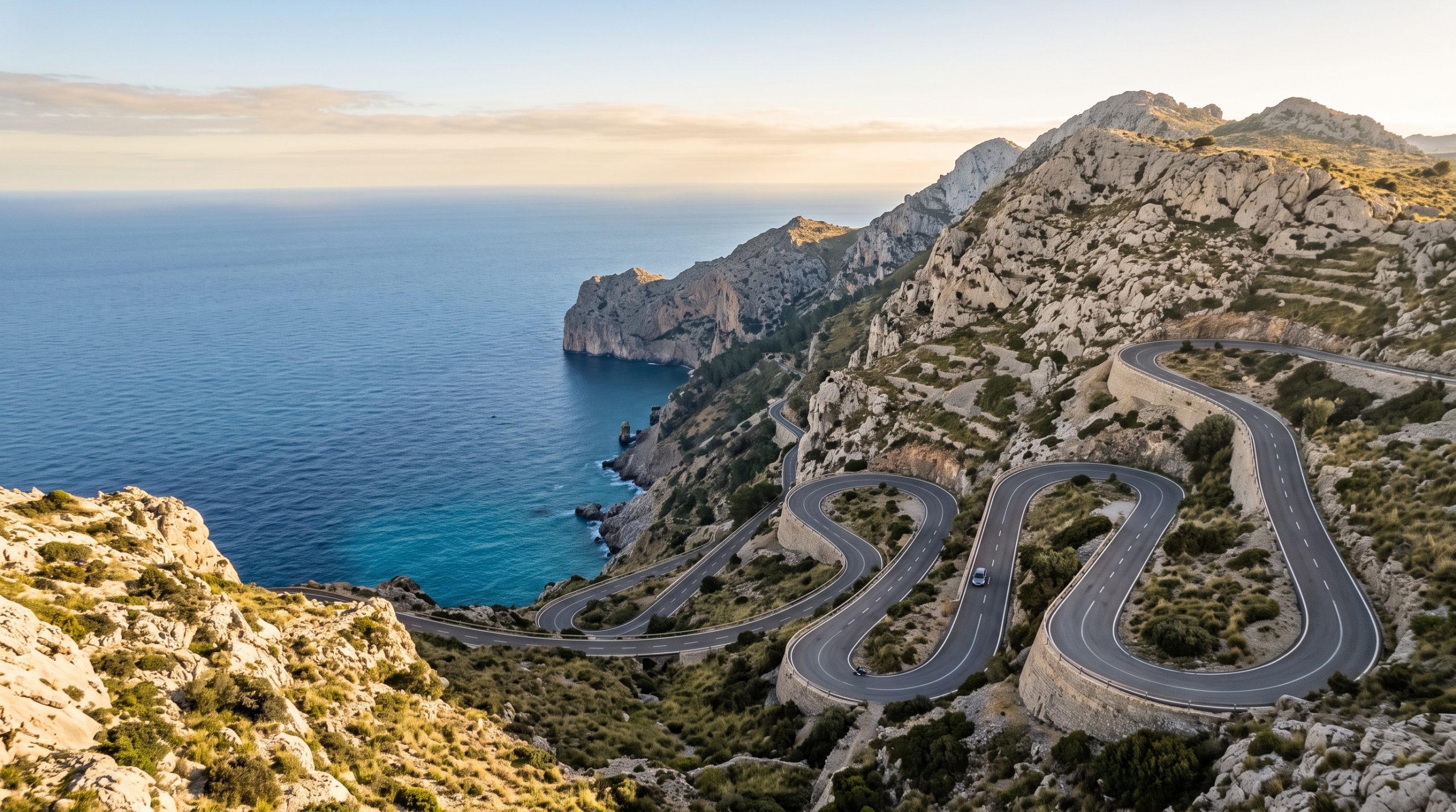
The road down to Sa Calobra drops 682 meters from Coll dels Reis to the water, and near the top it ties itself in a knot. One bend turns a full 270 degrees and passes underneath itself. The Nus de sa Corbata, the knot in the tie. On a map it is a grey squiggle about two centimeters long.
That squiggle is why couples who build a Tramuntana day off a route planner spend the day driving instead of standing still somewhere good. The app measures asphalt. It does not measure the group of cyclists spread across a hairpin on Coll de Sóller, the coach easing back into a passing place, or the fact that most of the Ma-10 has no shoulder at all, so you cannot simply pull over when the light starts doing something worth watching.
So here is the arithmetic we work with in the Serra de Tramuntana: the real distances, the times we actually write into a timeline, the two hours of the day the roads decide for you, and where to sleep so that none of it has to start at 4am.
The honest arithmetic of a Tramuntana day
Plan on moving through the Serra de Tramuntana at roughly half the speed a route planner promises. Sóller to Sa Calobra is about 38 km and we allow 90 minutes for it, not 40. Two locations fit comfortably into one day, three only if they share a valley. Everything left over is buffer.
What the Tramuntana hairpins add to the estimate
The Ma-10 is the spine of the range, running west to east from Andratx to Pollença across roughly 110 km of UNESCO-listed limestone. End to end, with no stops at all, it is a three-hour drive. That number alone should tell you it is not a transfer route. It is a day out, and treating it as a way of getting from A to B is the single most common planning mistake we unpick.
The gap between app time and road time is widest in three places. On the climbs, because Coll de Sóller and the Sa Calobra spur are two of the most ridden cycling roads in the Mediterranean and you will be sharing a lane with riders who have earned it. At the viewpoints, because the Nus de sa Corbata and a dozen unofficial pull-ins collect stopped cars all day. And on the descents, where limestone dust and a little rain turn a twenty-minute drop into a slow, deliberate one in low gear.
Two routes over the range deserve naming. The Ma-11 tunnel into the Sóller valley is a little over three kilometers of straight, well-lit road, and it has been toll-free since the end of December 2017, so there is no barrier and no queue at one. Above it sits the old pass, the Ma-11A over Coll de Sóller: 10.7 km, 52 hairpins, a summit at 508 meters, and almost no traffic since the tunnel opened in 1997. It is the better drive of the two by a wide margin. It is also the wrong choice on a morning that has a ceremony hour in it. Drive it the day before, in ordinary clothes, with nowhere to be.
| Leg | What the app says | What we plan on | Why the difference |
|---|---|---|---|
| Palma airport to the Sóller valley, Ma-11 tunnel | Under 40 minutes | 50 minutes | Motorway, then narrow village streets and awkward parking at the far end |
| Sóller to Sa Calobra, about 38 km | 40 minutes to an hour | 1 hour 30 | The reservoir stretch past Cúber and Gorg Blau, then the spur, then finding a space |
| Pollença to Sa Calobra via Lluc, about 42 km | 1 hour 20 | 1 hour 45 | Monastery traffic, then the same spur from the other side |
| Coll dels Reis down to Sa Calobra and back | 40 minutes return | 1 hour 15 return | 682 meters of descent, more than 50 bends, and the climb back out is slower still |
| Port de Pollença to the Formentor lighthouse, just over 19 km | 35 minutes | 1 hour | Mirador stops, and in season the road has to be cleared before the middle of the day |
| Andratx to Pollença, the full Ma-10 | 3 hours | A whole day, not a leg | 110 km of bends with nowhere to stop for most of it |
The right-hand column is what goes into the timeline, and it is the reason a Tramuntana day feels unhurried from the inside even though the roads are anything but.
Coll dels Reis: 682 meters down to the sea
The Ma-2141 leaves the Ma-10 at Coll dels Reis and gives back every meter of that height in more than fifty bends, most of them hairpins. It is a genuinely good drive and a slow one. Take it in low gear rather than on the brakes, expect cyclists, coaches and scooters in equal measure, and accept that the climb back out takes longer than the way down.
At the bottom, the last stretch into the port is a residents’ access zone with plate-recognition cameras at the entrance, so you park where the signs tell you to. Escorca council runs paid parking here and at neighboring Cala Tuent, and coins are worth having in the door pocket for the whole west coast. From the car park you walk to the cove on foot, through tunnels cut into the rock, and come out where the Torrent de Pareis meets the sea between limestone walls that rise as much as 200 meters.
Now the part a brochure will not tell you. At two in the afternoon in August, that cove is a queue for a tunnel and the light is flat and vertical. At seven in the morning it is empty, the walls are still holding shadow, and the water at the gorge mouth is the only bright thing in the frame, which is exactly the picture people come here for. You can see how that hour behaves in our published stories and films. If a dawn start is not your idea of a good morning, say so early and we will either build the coastal hour at Cala Tuent instead, where the crowd never really arrives, or move the whole thing to a month when the cove is quiet at a civilized hour.
The ten o’clock gate on the Formentor road
The Ma-2210 runs just over 19 km from Port de Pollença out to the lighthouse at Cap de Formentor, and through the high season it is not yours to drive whenever you like. Private cars, rental cars and motorcycles are kept off it during the middle of the day, currently from 10:00 until 22:00, with the season set each year by the DGT, Spain’s traffic authority, and recently running from the middle of May into the second half of October. Outside those hours the road is open to everyone. A TIB shuttle bus covers the peninsula while the restriction is live, taking around an hour from Alcúdia.
Read that as an invitation rather than an obstacle. A first-light ceremony on the cape is one of the most straightforward things to arrange in northern Mallorca, because the one hour nobody is allowed to compete with you is the hour before ten. An 11am ceremony at the lighthouse, on the other hand, is not a plan we can build in July. We treat ten o’clock as a hard wall, aim to be back through Port de Pollença by nine, and put breakfast after the ceremony instead of before it.
Which valley to sleep in
Where you stay decides how early you get up, and in this range that matters more than the quality of the room. The pattern we see fail most often is a base in Palma with all the locations north of the mountains, which quietly adds the tunnel twice to every day. Our planning fundamentals go into how the sleeping decision drives the rest of the timeline.
| Base | What it puts within reach | The trade-off |
|---|---|---|
| Sóller and Port de Sóller | The Sa Calobra spur, the reservoirs, the tunnel back to the airport | The valley holds cloud in the morning longer than the coast does |
| Deià | Cliff coast, terraces, a very short drive to the sea | Small village, tight parking, no room for a convoy of cars |
| Valldemossa | Palma in half an hour, the western Ma-10 immediately | Village car parks charge by the hour, and cash still rules |
| Port de Pollença | The Formentor road before its gate hours, Lluc, the northern Ma-10 | Sa Calobra is a 1 hour 45 commitment from here, each way |
| Palma | Flights, guests arriving late, restaurants | Every mountain location costs you the range twice in a day |
Aerials over a UNESCO landscape
Drone work in Mallorca sits under Spain’s aviation authority, AESA, and the airspace around Palma airport reaches across a wide slice of the south of the island. The Tramuntana adds its own layer, with nature protection zones inside the UNESCO landscape, and busy beaches across the Balearics are closed to open-category flying. None of that is a reason to skip aerials. It is a reason to name the exact spot and the exact hour early, so the permissions and the land manager are settled long before we design a sequence around them.
The buffers we build in, and what they buy you
A ceremony hour never sits next to a constraint. That is the rule everything else hangs from. If the Formentor road closes to cars at ten, we are off it by nine. If the day finishes at Sa Calobra, we climb back up the spur while there is still light to climb in, not after.
Then a reserve location, within fifteen minutes of the first, chosen for a different wind direction. The Tramuntana is a wall running the length of the coast, and it makes its own weather: the Sóller valley can be under cloud while Formentor is clean, and the reverse happens just as often. Holding a second option fifteen minutes away costs nothing on the day and saves the morning perhaps one time in five.
Two of us on the ground changes what all that driving means. On an Expedition day, with a dedicated photographer and filmmaker, we usually run two vehicles rather than one. While you are still finishing coffee in Sóller, one of us can be at the top of the spur seeing what the cloud is doing to the Torrent de Pareis, so the order of the day gets adjusted before you have left the valley. A second set of bodies and lenses in the other car matters most exactly where you would expect it to, which is 90 minutes of hairpins from anywhere that sells a spare. We are a team of eight, so there is always a colleague in reserve as well.
Coverage is one price whatever the drive turns out to be: The Adventure from $4,900 with one dedicated photographer or filmmaker, The Expedition from $7,900 with both working together, our flights and accommodation included either way, and the rest set out on the pricing page.
Send us the two or three places you have saved and the month you are thinking about, and we will tell you honestly which combinations fit into one day of Tramuntana driving and which need a second. Tell Us Your Story.
Common questions
How long does the drive from Palma airport to Sóller really take?
The Ma-11 and its tunnel, a little over three kilometers and toll-free since the end of 2017, is the quick way through the range, and an app will quote you under 40 minutes. We plan on 50, and closer to an hour if there is luggage and a hire car desk involved. The old pass over Coll de Sóller is beautiful and roughly triples that.
Can we drive out to the Formentor lighthouse on the morning of our elopement?
Before 10:00, yes. In high season the Ma-2210 is closed to private vehicles from 10:00 until 22:00, so the practical shape is a first-light ceremony at the cape and a drive back through Port de Pollença before the gate hours begin. The season dates are reset each year, so we confirm them for your date rather than assuming last year’s.
Do we need an automatic car for the Sa Calobra road?
No, but automatics are the smaller share of Spanish hire fleets, so reserve one months ahead rather than weeks if neither of you drives a manual. Take the smallest car that fits your party comfortably. On the descent from Coll dels Reis, low gear is worth more than a big engine.
Is the Sóller train worth building the day around?
As a piece of the day, not as its backbone. The vintage train covers the 27 km from Palma in about an hour, and the earliest summer departures leave mid-morning, which is after the good light in the valley has gone. We use it for an afternoon or the day before, and drive the ceremony hours.
How many Tramuntana locations fit into one day?
Two, properly. Three works when they share a valley, such as Deià, its cliff coast and one terrace above the village. Once the second location is on the far side of Puig Major, you are buying road time with light you would rather spend standing still, and that is when the Odyssey shape over several days starts to make more sense.
Do we need permission to fly a drone in the Serra de Tramuntana?
It depends on the exact location, the airspace above it and the landowner, which is why we ask about aerials at the start of planning rather than in the last week. We handle the research and the applications; government, venue and landowner fees are paid by you.
Send us the month and we will send you the roads
Our calendar is open across 2027–2029. From the first inquiry to your morning on the Ma-10, the planning stays in writing and on your time zone: the first reply and brochure come back by the next day, then a proposal built around your dates and a 30% retainer to hold them. If you are still deciding between coasts, our destination guides are the place to browse next.
Tell us the month, the hour you are willing to get up, and the two places you cannot leave out, and we will build the timeline backwards from the light. Check Your Date.